Well, not hell, exactly. Unless hell is lush and green and sparsely populated…
Hell, in this instance, was not a location, but the Twilight Zone experience of my ride this morning to the Lehighton area. My fault, it was pointed out, for trusting the GPS. But the purpose of a GPS is navigation and so I permitted the instrument to dictate my travels. I paid good money for it. I ought to have a little trust in the system.
Yes. My fault.
I freely admit that now, although in the course of my travails—er, I mean my travels—I cursed that GPS with every name imaginable. But I should start at the beginning and proceed in proper order, the ways the roads would in a perfect world.
My writer’s group met at the home of one of its members today. I had a basic idea how to get there. The route was, in fact, rather direct, but I drove in the opposite direction to the grocery store to obtain a fruit platter and opted to use my GPS to find the way from that point. I took the “no toll” option. Made sense. The road I needed to travel didn’t have tolls. I figured this choice would put me on the right path.
Mistake. I recognized straight away that my car and I were not on the right path. However, I also knew generally where I was and with roads bordered by lovely scenery and in excellent shape, I saw no reason not to follow the whim of the female voice coming from the box on my dashboard.
Though meandering, I trusted (there’s that word again) I would get to my destination and enjoyed the ride. The little clock at the corner of the screen showed a thirty-nine minute ride. Right on schedule.
I passed through Alburtis, a perfectly picturesque little town not far from where I live, but which I’ve never had the opportunity to visit. I want to go back. I suppose this means trusting my GPS again. We’ll see. I won’t bore you with a blow-by-blow, but suffice it to say I eventually reached Route 309. Hoorah! All I needed to do was take a left and head north until I came to the next turn and then, seven or eight miles later, to my friend and fellow writer’s driveway.
My GPS had other ideas. Okay, I thought. A little exploration could be fun. Right?
Yeah. Loads.
It started out that way. I turned left and right on tree-lined lanes with charming names like Blue Mountain and Bake Oven. Then there was sudden misdirection which should have been an indication. I was told to bear left on a certain road which turned out to be a left hand turn so sharp it almost went backward. The second indication there could be a problem was the big yellow sign that read: Road Under Construction – Travel at Your Own Risk. Being addled by the lovely scenery, I assumed that to mean the road was being repaired and carried on. I drove slowly over a fifty-foot stretch of rough paving back onto smooth surface. Huh? Was that it? What a silly sign.
Suddenly, the condescending witch in my GPS told me to make another left. There wasn’t another left. There was a right and a straight. I chose the straight, and soon realized when the sign said the road was under construction that was exactly what it meant.
I backed up and promptly dropped the rear tire off the side of the road into a rain-washed gully. With a bit of earnest prayer I managed to get back on the road, turn around and head back out to the main highway. There had to be another road over the mountain, right? Not so fast, toots. Next was a dead end. I turned around and went back to the highway once more, forgoing the road under construction, as well as the next one which I knew (being smarter, I told myself, than a GPS) led to the same road under construction. I drove another mile to the prettily named Ashfield Road. Aha! Success. Clear sailing. Smooth pavement. I’d be over the mountain in no time.
No. It came out on the ravaged road as well. This time, though, the GPS was calling it Ashfield rather than Reservoir Road. Oddly, though, the actual street sign said Frank. I knew I was in the same place, however, because I had come upon an antique car parked catty-cornered to the meeting place of these two roads. The vehicle looked to be from the 1920’s, pristine condition, with a few yellow helium balloons affixed to it bobbing gently in the drops of rain. Did I not mention seeing that before? I certainly should have, because as soon as I saw it again—a beautiful piece of antique machinery a couple of miles from the nearest habitation—I began cursing so profusely and imaginatively at the #$%*&#* GPS that I forget the photo op altogether and decided, in my fury, to travel the Unconstructed Road. How bad could it be?
As I’ve said above, Apparently All Roads Lead to Hell. At least in this section of Lehighton.
It wasn’t, though. Not hell. Not really. Just an unpaved, sparsely graveled, pitted, gullied, collapsing stretch of trail awaiting blacktop at some distant future date. My GPS was telling me I had to stick with this mess for another four miles. Four miles that took me thirty minutes to traverse. Oops. Behind schedule now. Two huge SUV’s passed me coming the other direction. I had to stand my ground or drop off the side. They were better outfitted to ease around my own, smaller, ill-equipped-for-such-stupidity motor vehicle. Being a sucker and not learning from my mistakes, I took their presence as a good sign as well. That was, until I saw the hiker with his walking stick and backpack. This was followed by a particularly huge rock in the road. I crawled past it with one thought: How did that get there? I looked up, then, and saw two spindly trees holding back a huge fall of boulders—and did I tell you torrential rain was coming? I began to swear again, but quickly took to laughing. (Can you say hysteria?) And all this time, I was driving up, up, up at a ridiculously steep angle.

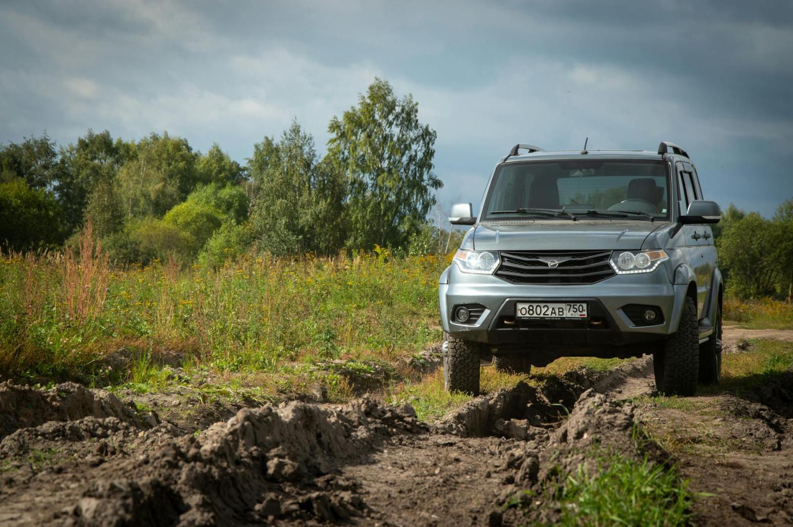
Finally, the road leveled off. See picture at right—one of the only ones I took, daring to remove my hands from the steering wheel long enough to pull out my phone while stopped for a much needed respite from white knuckles and hyperventilation. Beautiful, yes? Green and lush and, well, you get it—anywhere else I would have broken out a picnic lunch.
The road was more evenly graveled here, almost wide enough for two cars. Piece of cake. Until I saw the fog ahead and remembered I now had to descend. I won’t give you all the details of the gullies, the positioning of my wheelbase in such a fashion that I could pass over the ruts, the hint of sunlight through the fog and trees to my right indicating a steep drop off… When I reached the bottom I breathed a sigh of relief. The dog chasing my car from a junkyard I could view as comical, the post office a sign of civilization—except for the lack of a town’s name across its brick front. Still, the road had become potholed blacktop. I had made it!
In short order, I reached another main road and took the left hand turn directed by my female non-companion and found myself a quarter mile from my destination. The GPS hadn’t misdirected me after all. She’d only displayed a really nasty sense of humor.
Discover more from robin maderich - write-brained scribbler and crafter-on-the-loose
Subscribe to get the latest posts sent to your email.
